
Chesapeake Bay Voyage: Tyler Cove to Wenona
The Chesapeake Bay Voyage is a series of kayak trips, with the goal of paddling the entire length of the bay from north to south. It is taking place over several weekends during the warm seasons of 2014.
Is this July?
The question came up multiple times throughout our trip. Heat, humidity, bugs, and typical summer unpleasantness were all blissfully absent. We skipped the DEET and bug nets. We wore long pants and sleeves in the evening, and crawled under the covers in our tents. The breezes were just enough to feel refreshing, and not so much as to impede our paddling progress. For two days we kept telling ourselves, it just doesn’t get any better than this.
Day 10 (Fri 7/18/2014): Tyler Cove to Lower Hoopers (15.4 miles)
Peter and I met the group at Tyler Cove landing, at the very southern tip of Taylors Island. Loading and launching into Fishing Creek, we set out on a path down the Honga River. Collectively known as Hoopers Island but actually comprised of three islands, Hoopers Island is one of those remote places where even the Google Street View car didn’t venture to go. There’s one road in, which only gets you to 2 of 3 of those islands, and you gotta take the same road back out. It’s home to watermen, seafood packing companies, one general store, and one restaurant called Old Salty’s. Cyclists like to go there, because the road becomes a narrow causeway with water views on both sides, and you can count the cars that go by on one hand. The first colonists were three generations with the same name: Henry Hooper (who by the way had fourteen children), the second Henry Hooper, and his son Henry Hooper, Jr. Figure THAT out!?!
We detoured to check out Wroten Island, which has a small airplane landing strip on the western edge. Then we ducked out under the bridge between Upper and Middle Hoopers, but not before stopping in the shade under the bridge deck for some lunch. Why is the arch so high, we wondered? There were no recreational boats in sight on a beautiful summer Friday, so we guessed the bridge was built to accommodate skipjacks (with masts) that might sail the Honga River. The bridge supports, made of steel and horribly rusted, had been reinforced with outer metal casings filled with concrete. And a thick bed of oyster shells had us wondering if they paved the way to a former ferry landing. Dave spotted a rainbow (or sunbow, since there was no rain?) up in the blue skies streaked with wispy clouds.
After lunch, we cruised down the west side of Middle and Lower Hoopers. Ferries used to serve the islands, but were later replaced by the road. Lower Hoopers Island was once a thriving community called Applegarth of more than 100 residents, but erosion drove them away by the late 1920s, and once the bridge washed out in a 1933 hurricane it was never replaced.
Yeah, this will do!
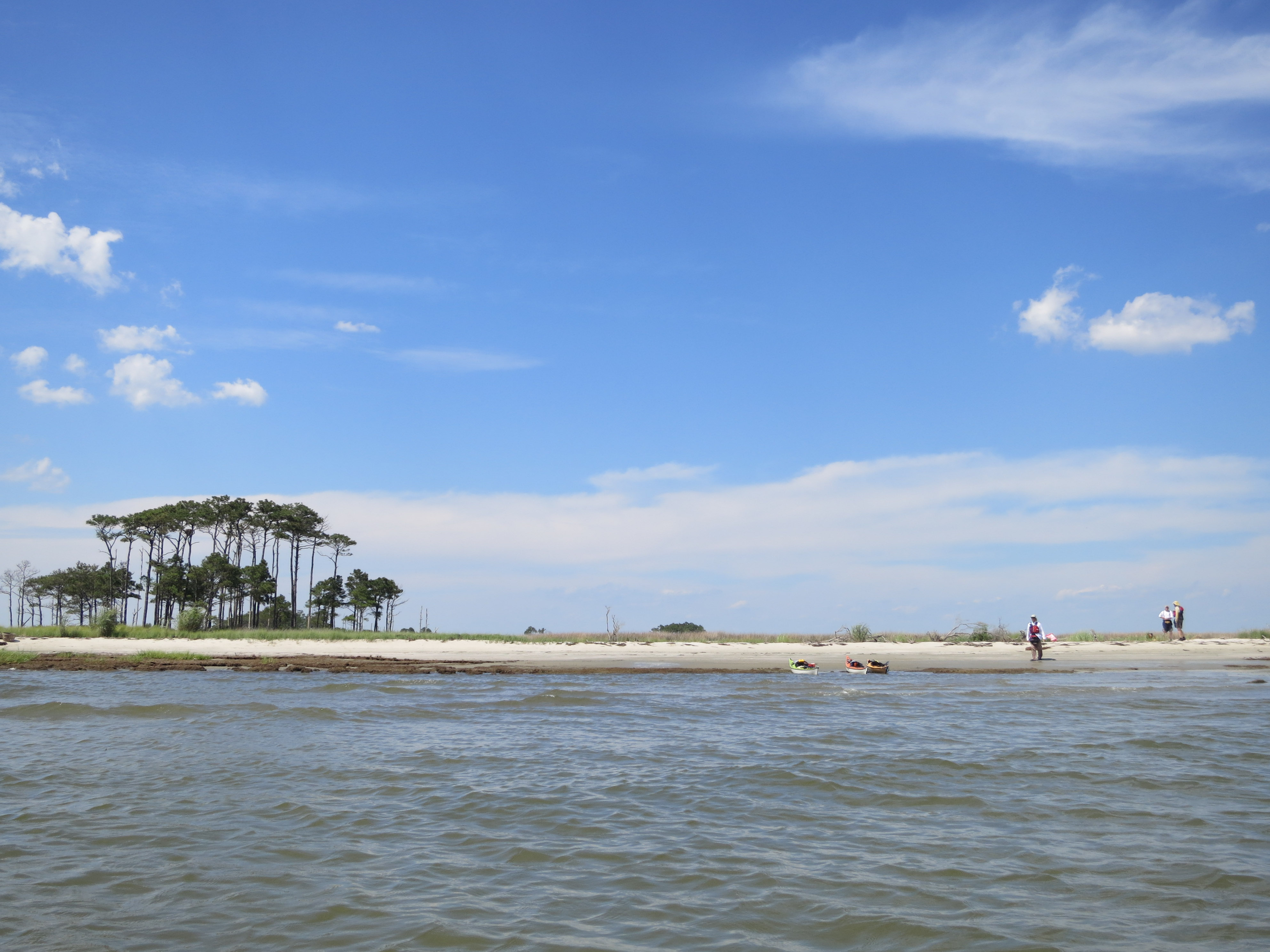
After scouting a couple of beaches, we settled on the big one at Nancy’s Point and pitched our tents (leader Dave having gotten prior permission from the landowner to do so). Paddlers emptied their boats and relaxed for awhile, then set off for an evening circumnavigation of Lower Hoopers. On the south end we paused with charts, compass, and binoculars to interpret the landmarks and scout our route the next day.
Back at our white sand beach, Jim recruited Peter to collect firewood, which he amassed in a bushel basked buried in the sand hoping for a nice beach fire once evening fell. By dinnertime though, the winds had picked up and shifted enough that wandering sparks would blow right towards our tents and the marsh grass, so we wisely decided to forego the campfire. We used our rain fly on the tent but kept the doors open, permitting the increasing breezes to blow right through.
Day 11 (Sat 7/19/2014): Lower Hoopers to Wenona (18.6 miles)
Those up early enough got to watch the sunrise, pelicans flying in formation overhead, and a pod of dolphins cruising past the beach. The rest of us awoke in time for breakfast and coffee in a breezy, bug-free environment. We packed up and launched around 8:30 am, on a bearing towards the Hooper Strait light. Its rusty and unattractive platform once supported a historic screw-pile lighthouse, which now lives at the Chesapeake Bay Maritime Museum in St. Michaels, MD.

Hooper Strait light, a skeleton of its former self.
When we hit the beach on Amos Bar below the Hooper Strait light, everyone marveled at the invisibility of Bloodsworth Island to our south. On the charts, it’s a huge expanse of land, to be diligently avoided due to Navy bombing practices. From the water, it’s hard to tell what’s there to avoid. Very few trees remain, and only when due east of the island were fragments of land discernible on the horizon. As everyone stretched and snacked, I pulled out my copy of “Disappearing Islands of the Chesapeake Bay” and read the chapter about Bloodsworth Island aloud to those within earshot. It had changed hands many times since it was settled, but the land proved quite poor for any kind of farming. Once oystering was no longer profitable, the entire island was acquired by the U.S. Navy and subsequently sacrificed for bombing drills and Seal training. Those in our group with military backgrounds told what they knew of those practices, but said they have largely stopped in recent years. It’s rumored that herons and egrets have populated large rookeries there, but of course few get close enough to verify the presence of wildlife.
Continuing south past Bishops Head Point, Peter and I paused at a white farmhouse and large brown building, the only structures on that expanse of land. They turned out to be the Karen Noonan educational center owned by the Chesapeake Bay Foundation.

Chesapeake Bay Foundation’s Karen Noonan Center
From Bishops Head, the group collected and assessed the conditions at the mouth of the mighty Nanticoke, which we needed to cross. Winds were still manageable and not predicted to increase, so we felt comfortable taking off for Deal Island. This was one of the longest crossings we’d done yet, about 7 miles over open water with light winds in our face and current pushing us downriver towards the bay. There were moments it seemed like a never-ending slog, but eventually the dots on the horizon that we aimed for turned into buildings and bridges and other recognizable features. We adjusted our angle to meet at the right end of the bridge from Chance to Deal Island, where everyone was relieved to take a break on a nice public beach.
Two young girls, visibly curious about our boats, approached me to ask questions. I let them sit in the cockpit, hold my Greenland paddle, and told them the simple details about our trip. They seemed impressed, and their mom smiled, conversationally wondering if she’d be buying kayaks sometime in the future.
During our much-deserved break, we debated whether to finish our trip on the outside of Deal Island, or take the inside passage. The outside would be a shorter distance, mostly past waterfront houses and bulkheads, but the inside track would take us past the Chance marina (where there were no fewer than three skipjacks), through a winding marsh, and mostly stay out of the wind. Most of us felt like they’d seen enough of the Chesapeake’s open water for one day, and voted for the longer route with more interesting scenery. Past town, through and around some uninhabited marsh dotted with fish weirs, we coasted into Wenona Harbor with the wind at our backs, a nice way to end an 18+ mile day.
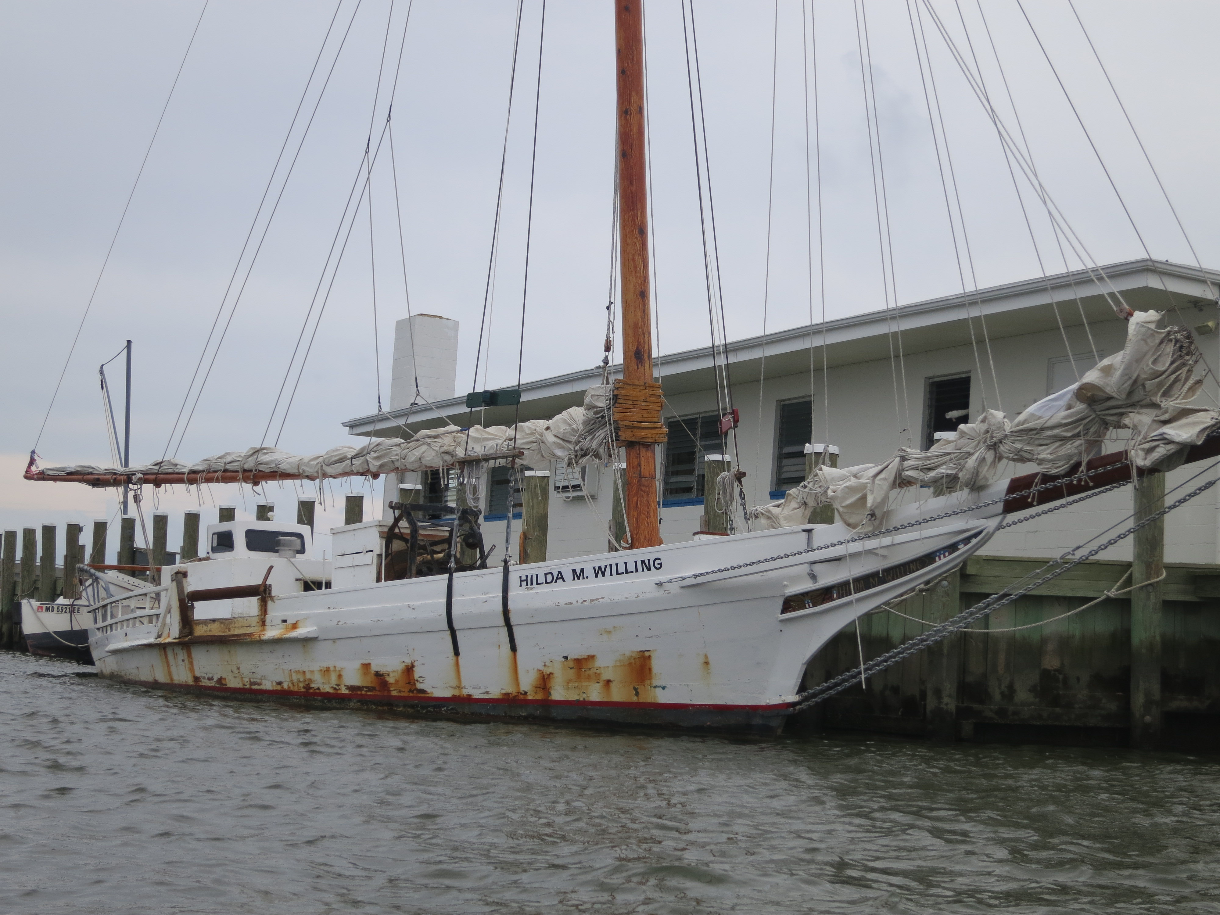
One of five Skipjacks seen on this trip
Finishing our trip around 4:00 PM, we were tired and in no hurry to leave, and began the orderly process of packing up. Even with the late additions, there were enough cars and boat racks to haul everyone back to the start. Once we’d retrieved my car again, Peter and I wandered into Cambridge to see what restaurants were open. We wound up having two excellent wood-fired pizzas at a new place called Stoked. Our waiter was a fourth generation resident of the area, and had a lot to say about why Cambridge seems to fall behind its neighbors Easton and St. Michaels in economic success. For good food, great stories and local insight, ask for Eric.
